Nature FIRST (2022–2025) was a Horizon Europe project that developed practical tools to help practitioners protect nature more effectively. Working across six biogeographical regions, including the Carpathians, Stara Planina, the Danube Delta and Ancares–Courel, the project combined ecology, environmental forensics, remote sensing and artificial intelligence.
Its goal was to deliver tools that enable:
early detection of environmental change
better biodiversity monitoring
improved human–wildlife conflict (HWC) prevention
stronger responses to wildlife crime

SSF played a central role in impact creation, stakeholder engagement, and ensuring long-term use of project results.
status: finished
problem
The decline of biodiversity is one of the most urgent problems facing humanity. Biodiversity encompasses the variety and variability of life on earth — all the animals, plants, fungi and microorganisms that work together to make up the different ecosystems that exist. Unfortunately, as we put more and more pressure on the planet, biodiversity is declining at an alarming rate.
To effectively address biodiversity loss, nature conservation efforts must be informed by a deep understanding of what is causing it, along with which strategies are effective for conservation and restoration purposes. In short, we need a better understanding of why and where biodiversity is declining and what the key triggers are.
solution
Nature FIRST developed predictive, proactive and preventative capabilities for nature conservation stakeholders by combining theoretic premises from the sciences of ecology and environmental forensics with empirical environmental observations (satellite-based and on-site) into a Proof of Principle that was tested and demonstrated in four European areas, covering six biogeographical regions.
The project proposed a model-driven, continuous form of ecosystem monitoring that assessed not only species numbers and ecosystem state, but also the modelled ecological and anthropogenic processes within an ecosystem and their interactions. This approach made it possible to identify cause–effect relations and improve monitoring models through retrofits and simulations to understand changes more effectively. These models (also called Digital Twins) served as a means for learning and provided context to translate environmental observations (data) into facts and actionable information (intelligence) for site managers and policymakers
Impact and Outcomes
To make the tools genuinely useful for people working on the ground, we collaborated closely with rangers, protected-area managers, enforcement agencies and researchers. The project delivered:
-
A cost-effective, automated model that generates scalable and repeatable habitat maps using satellite data and field-based ground truth. It supports the classification of Natura 2000 habitats and other land-cover types and can be adapted for different regions and resolutions.
-
A service that identifies where, when and how human–wildlife conflicts occur by analysing spatial patterns of incidents. It helps practitioners understand conflict hotspots and underlying drivers, supporting more effective mitigation strategies.
-
A continuous, remote-sensing–based monitoring service that detects changes in habitat condition over time. It includes tools such as Environmental Time Series analysis to assess vegetation dynamics and conservation status.
-
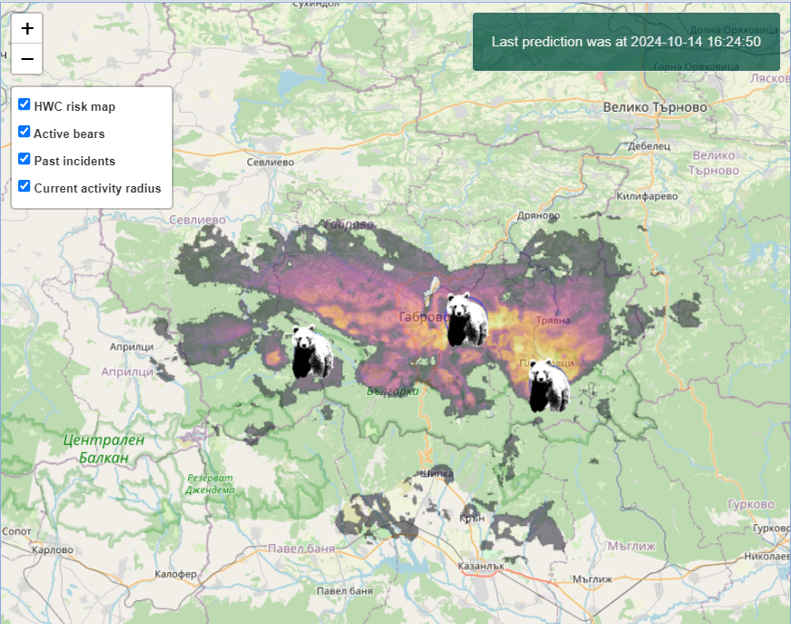
A predictive digital twin that provides near-real-time information on bear presence and potential conflict risk, helping communities and authorities anticipate and prevent dangerous encounters. It models bear movement, landscape factors and risk patterns.
-
An AI-driven semantic framework that links ecological data from multiple sources into a unified, interoperable structure. It enables better data discovery, sharing, ESG reporting and the development of stronger AI/ML models by harmonising diverse datasets.
-
A modular, field-ready toolkit that helps rangers and first responders secure wildlife crime scenes and preserve evidence under challenging conditions. It is supported by hands-on training and includes protocols, tools and guidance for use in real enforcement scenarios.
Although the Nature FIRST website will be retired, the project’s tools and methods continue through its partners: Sensing Clues (monitoring tools & Knowledge Graph): https://www.sensingclues.org; Wildlife Forensic Academy (forensic training): https://www.wildlifeforensic.com; 3eData (mapping & RPAS services): https://3edata.es/en/services/; WWF Romania (field-site follow-up): https://wwf.ro; WWF Ukraine (conservation programmes). With SSF’s focus on exploitation, communication and long-term impact, the results of Nature FIRST remain available and ready to support data-driven, collaborative conservation well beyond the project’s lifetime.
Consortium Partners
-
![]()
BULGARIAN ACADEMY OF SCIENCE
-
![]()
WORLD WILDLIFE FUND (Romania and Ukraine)
-
![]()
WAGENINGEN UNIVERSITY & RESEARCH
-
![]()
WILDLIFE FORENSIC ACADEMY
-
![]()
UNIVERSITY OF STAFFORDSHIRE
-
![]()
SENSING CLUES
-
![]()
DOTSPACE
-
![]()
GRAPHWISE
-
![]()
DANUBE DELTA NATIONAL INSTITUTE
-
![]()
SUSTAINABLE SCALE-UP FOUNDATION


Reports & documents
Below you can find public reports and documents related to the activities and governance of Nature FIRST:
partner with us
Would you like to join us in building the European Wildlife Forensic Network? Let us know!
Visit wildlifeforensic.com for more information!